
Showing posts with label Greece. Show all posts
Showing posts with label Greece. Show all posts
Wednesday, 23 July 2014
Acropolis of Athens, Greece

Monday, 14 July 2014
Oia - Santorini island, Greece

Source:Wikipedia
Tuesday, 27 August 2013
Santorini, Greece

Santorini (Greek: Σαντορίνη, pronounced [sadoˈrini]), classically Thera /ˈθɪrə/, and officially Thira (Greek: Θήρα [ˈθira]), is an island in the southern Aegean Sea, about 200 km (120 mi) southeast from Greece's mainland. It is the largest island of a small, circular archipelago which bears the same name and is the remnant of a volcanic caldera. It forms the southernmost member of the Cyclades group of islands, with an area of approximately 73 km2 (28 sq mi) and a 2011 census population of 15,550. The municipality of Santorini comprises the inhabited islands of Santorini and Therasia and the uninhabited islands of Nea Kameni, Palaia Kameni, Aspronisi, and Christiana. The total land area is 90.623 km2 (34.990 sq mi). Santorini is part of the Thira regional unit.
Source:Wikipedia
Sunday, 25 August 2013
Acropolis of Athens

Source:Wikipedia
Wednesday, 21 August 2013
Blue Caves, Zakynthos Island, Greece

Zakynthos (Greek: Ζάκυνθος, [ˈzacinθos] ( listen)) or Zante (from Venetian) is a Greek island in the Ionian Sea. It is the third largest of the Ionian Islands. Zakynthos is a separate regional unit of the Ionian Islands region, and its only municipality. It covers an area of 410 km2 (158 sq mi) and its coastline is roughly 123 km (76 mi) in length. The island is named after Zakynthos, the son of a legendary Arcadian chief Dardanus. The name, like all similar names ending in -nthos, is pre-Mycenaean or Pelasgian in origin. Zakynthos has a thriving tourism industry.
Source:Wikipedia
Wednesday, 7 August 2013
Melissani Cave, Kefalonia, Greece

Melissani Cave (Greek: Μελισσάνη) or Melissani Lake, also Melisani is a cave located on the island of Kefalonia, northwest of Sami, about 5 km SE of Agia Efthymia, NE of Argostoli and NW of Poros. The Ionian Sea lies to the east with the Strait of Ithaca. Forests surrounds the cave and the mountain slope is to the west. Near the cave is the entry to the cave with parking lots and is passed almost in the middle of the main road linking Sami and Agia Efimia especially to the northern part of the island.
Source:Wikipedia
Tuesday, 6 August 2013
Santorini, Greece

Santorini (Greek: Σαντορίνη, pronounced [sadoˈrini]), classically Thera /ˈθɪrə/, and officially Thira (Greek: Θήρα [ˈθira]), is an island in the southern Aegean Sea, about 200 km (120 mi) southeast from Greece's mainland. It is the largest island of a small, circular archipelago which bears the same name and is the remnant of a volcanic caldera. It forms the southernmost member of the Cyclades group of islands, with an area of approximately 73 km2 (28 sq mi) and a 2011 census population of 15,550. The municipality of Santorini comprises the inhabited islands of Santorini and Therasia and the uninhabited islands of Nea Kameni, Palaia Kameni, Aspronisi, and Christiana. The total land area is 90.623 km2 (34.990 sq mi). Santorini is part of the Thira regional unit.
Source:Wikipedia
Mykonos, Greecе

Mykonos Greek: Μύκονος [ˈmikonos]) is a Greek island, part of the Cyclades, lying between Tinos, Syros, Paros and Naxos. The island spans an area of 85.5 km2 (33 sq mi) and rises to an elevation of 341 m (1,119 ft) at its highest point. There are 10,134 inhabitants (2011 census) most of whom live in the largest town, Mykonos, which lies on the west coast. The town is also known as Chora (i.e. the Town in Greek, following the common practice in Greece when the name of the island itself is the same as the name of the principal town).
Tourism is a major industry, and Mykonos is particularly renowned for its cosmopolitan nightlife; many international celebrities visit the island every summer.
Source:Wikipedia
Sunday, 4 August 2013
Melissani Lake, Kefalonia, Greece

Melissani Cave (Greek: Μελισσάνη) or Melissani Lake, also Melisani is a cave located on the island of Kefalonia, northwest of Sami, about 5 km SE of Agia Efthymia, NE of Argostoli and NW of Poros. The Ionian Sea lies to the east with the Strait of Ithaca. Forests surrounds the cave and the mountain slope is to the west. Near the cave is the entry to the cave with parking lots and is passed almost in the middle of the main road linking Sami and Agia Efimia especially to the northern part of the island.
Source:Wikipedia
Rhodos Island, Greece

Rhodes (Greek: Ρόδος, Ródos, [ˈroðos]) is an island in Greece, located in the eastern Aegean Sea. It is the largest of the Dodecanese islands in terms of both land area and population, with a population of 115,490 (2011 census),[1] and also the island group's historical capital. Administratively the island forms a separate municipality within the Rhodes regional unit, which is part of the South Aegean region. The principal town of the island and seat of the municipality is Rhodes.[2] The city of Rhodes had 50,636 inhabitants in 2011. It is located northeast of Crete, southeast of Athens and just off the Anatolian coast of Turkey.
Source:Wikipedia
La Grotta Cove – Corfu Island, Greece

Corfu (Greek: Κέρκυρα - Kérkyra) is a city and a former municipality on the island of Corfu, Ionian Islands, Greece. Since the 2011 local government reform, it is part of the municipality Corfu, of which it is a municipal unit.[2] It is the capital of the island and of the Corfu regional unit. The city also serves as a capital for the region of the Ionian Islands. The city (pop. 28,185 in 2001) is a major tourist attraction, and has played an important role since the 8th century. The city has become known as a Kastropolis (Castle City) because of its two castles.[3] In 2007, the old town of the city was inscribed on the UNESCO World Heritage List.[4][5][6] The municipal unit of Corfu city has a land area of 41.905 km2 (16.180 sq mi) and a total population of 39,487 inhabitants. Besides the city of Corfu/Kérkyra, its largest other towns are Kanáli (pop. 3,556), Potamós (2,365), Kontokáli (1,616), Alepoú (1,606), and Gouviá (952).
Source:Wikipedia
Papafragas Beach – Milos Island, Greece
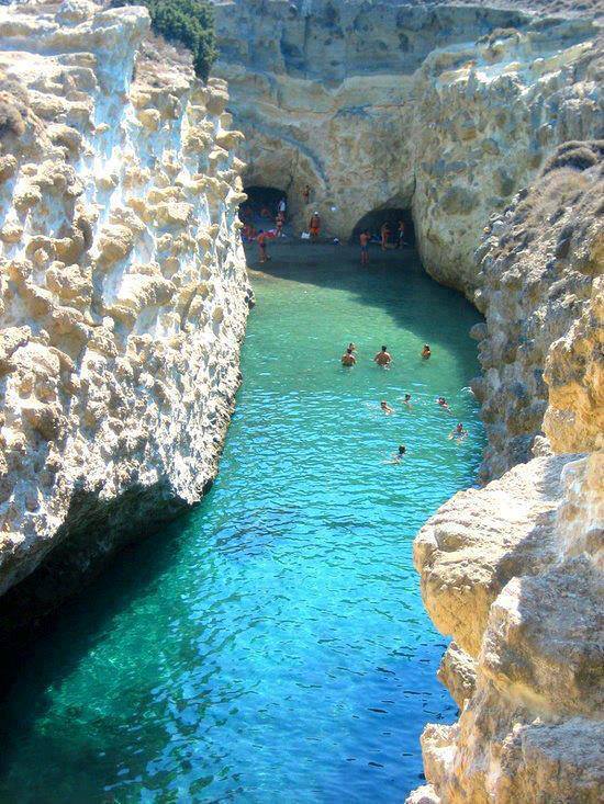
Milos (in Greek, Μήλος, older spelling Μῆλος Melos), is a volcanic Greek island in the Aegean Sea, just north of the Sea of Crete. Milos is the southwesternmost island in the Cyclades group.
The island is famous for the statue of Aphrodite (the "Venus de Milo", now in the Louvre), and also for statues of the Greek god Asclepius (now in the British Museum) and the Poseidon and an archaic Apollo in Athens. The Municipality of Milos also includes the uninhabited offshore islands of Antimilos and Akradies. The combined land area is 160.147 km2 (61.833 sq mi) and the 2001 census population was 4,977 inhabitants
Source:Wikipedia
The Navagio Bay, Greece

Navagio Beach (Greek: Ναυάγιο), or the Shipwreck, is an exposed cove, often referred to as 'Smugglers Cove', on the coast of Zakynthos, in the Ionian Islands of Greece and is the location of the wreck of the alleged smuggler ship Panagiotis
Source:Wikipedia
Subscribe to:
Posts (Atom)